Geographic ‘Space’ is one of the fundamental concepts that we humans have invented for making sense of, and mentally & physically structuring, our world and everything in it. Indeed for over 2,000 years we have been perfecting the art, science and visual language of cartography to record what ‘things’ of particular types exist within a defined space, both for ourselves so we can manage ‘our world’ (well our particular bit of it), and so we can easily communicate it to others.
.
Background
Imagine for a moment that geographic maps and cartography had not been invented and the only tool we all had to describe geographic space and the things in it was words alone……. Yikes!
And whilst you’ve got your thinking hat on, think about the relationships between those different geographic ‘spaces’ we all live in and how we describe that location. It’s pretty much always relative and hierarchicial (often what’s called a ‘nested hierarchy‘).
For example in response to the question “where are you?”, you’re currently probably reading this sitting in a room, which is in a particular building, which is on a particular street, which is in a particular town or city, which is in a particular county, which is in a particular state, which is in a particular region, of a particular nation, which is in a particular geographic sub-region of a particular bigger macro region (‘continent’), which is part of the wider world, which is a particular planet called Earth, which is part of a particular planetary system called the Solar System, which is in a particular galaxy called The Milky Way etc., etc. In other words your response to the question “where are you?” will depened on the scale the person that asked it had in mind, as all these locations are true.
Anyway the point is that visually capturing relative hierarchicial relationships between all the ‘things’ that make up a particular ‘space’ is something that MindManager does especially well (indeed was the sole reason it was created at the time).
And as long time, power users familiar with all of it’s many ‘information cartography’ features, who are also even longer time users, analysers and creators of geographic maps and the information that makes them up, we could see the potential for using MindManager to not just map the different ‘building blocks’ that make up particular geographic spaces, but also the official / definitive / ‘plain old useful’ public domain knowledge resources about them (along with their world wide web addresses ie. URLs). You know, the things that we all waste so much of our precious time searching for online. Time that we / our team / our organisation / our community would much rather spend actually using the knowledge to do what we need to do to move forward and make our contribution to this big old beautiful world of ours 🙂
And so we decided to see how far we could take this ‘geographic knowledge mapping’ premise….
You can read more about our journey of exploration in the ‘Background’ tab of our Map Guide, but the ‘Countries of the World Knowledge Atlas’ maps we offer here in our Map Store, are where we’ve got to so far on it….
.
Countries of the World Base Knowledge Atlas Map Creation
The premise is simple (even if the maps look big and complex to those unfamiliar with information mapping) – use MindManger to create the knowledge map equivelant of the geographic map of the Countries of the World we are all familiar with.
These are the basic steps in the map-making process…
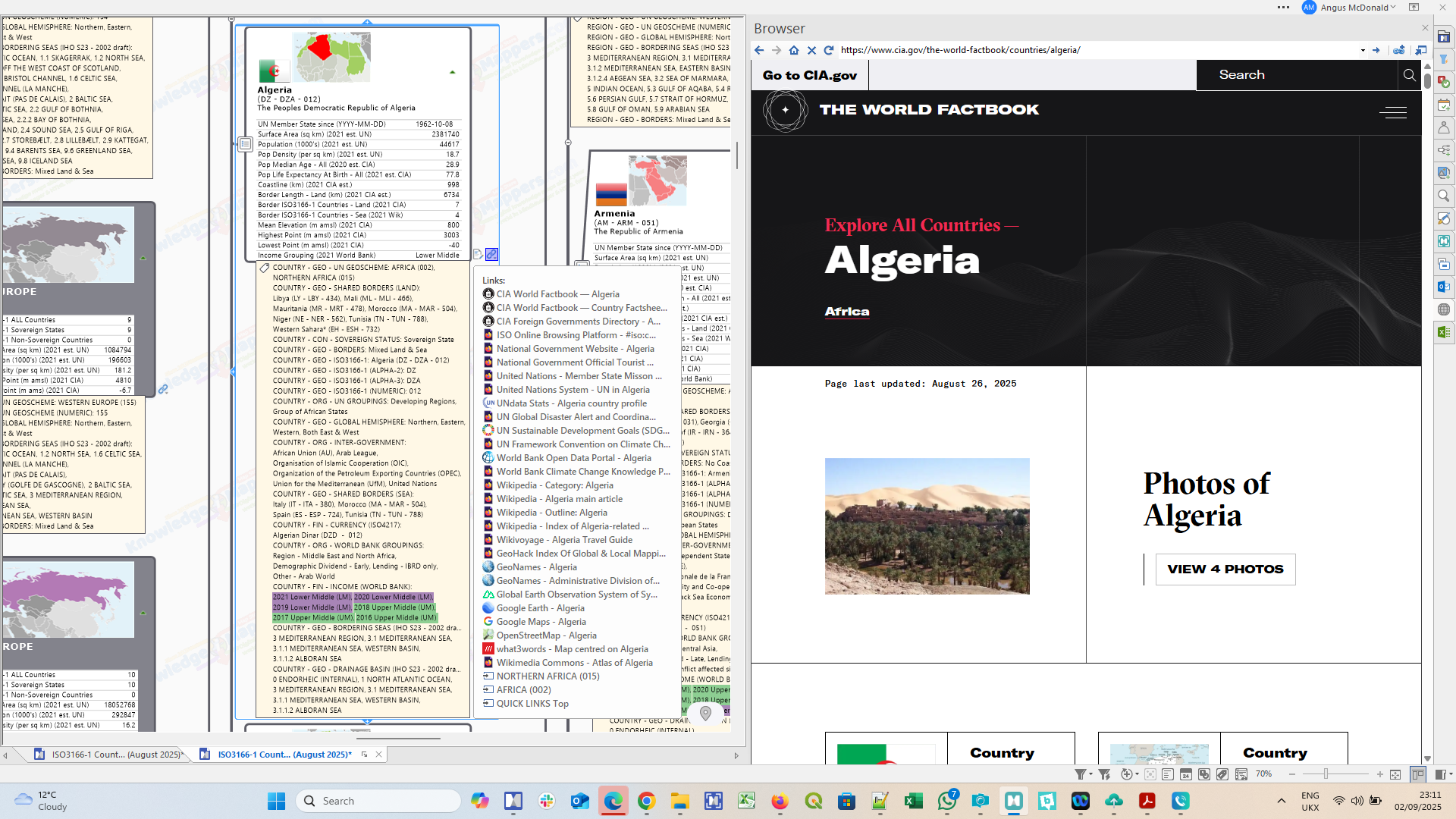
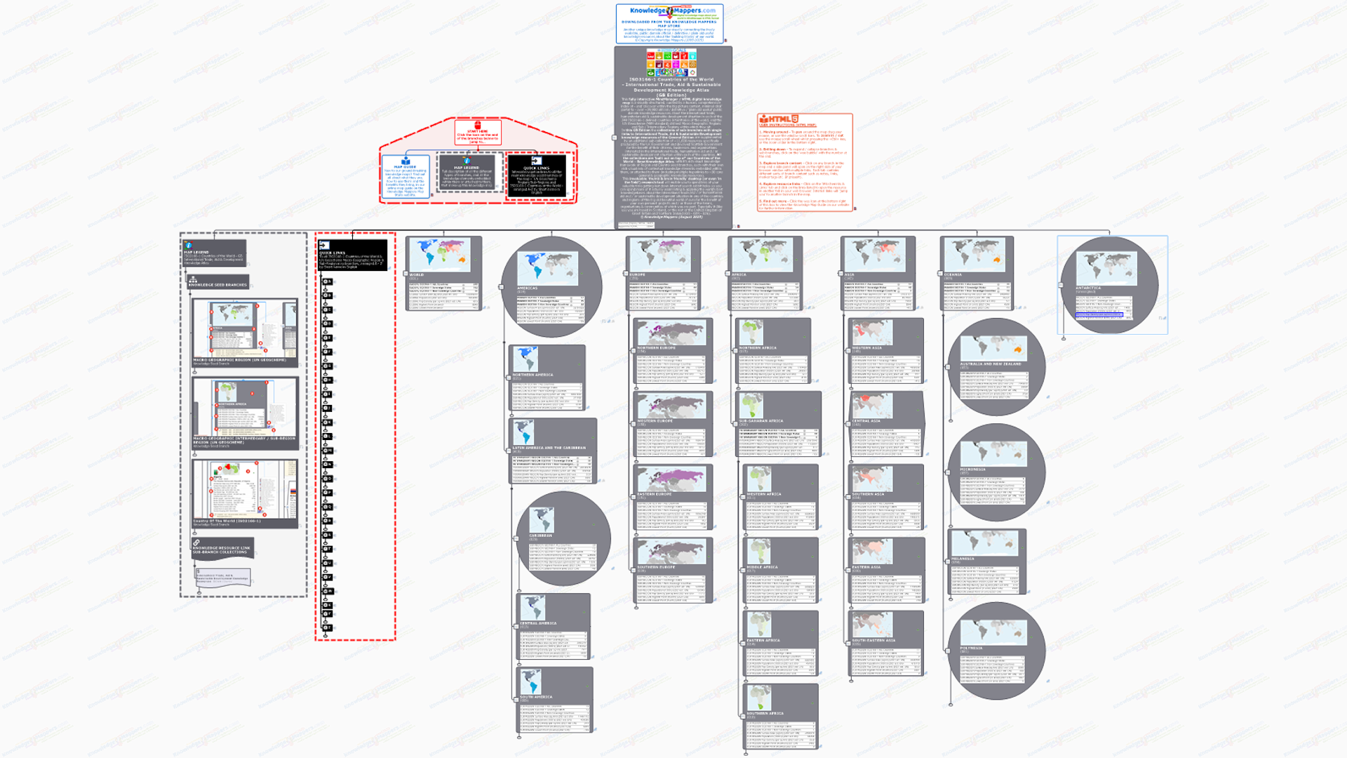
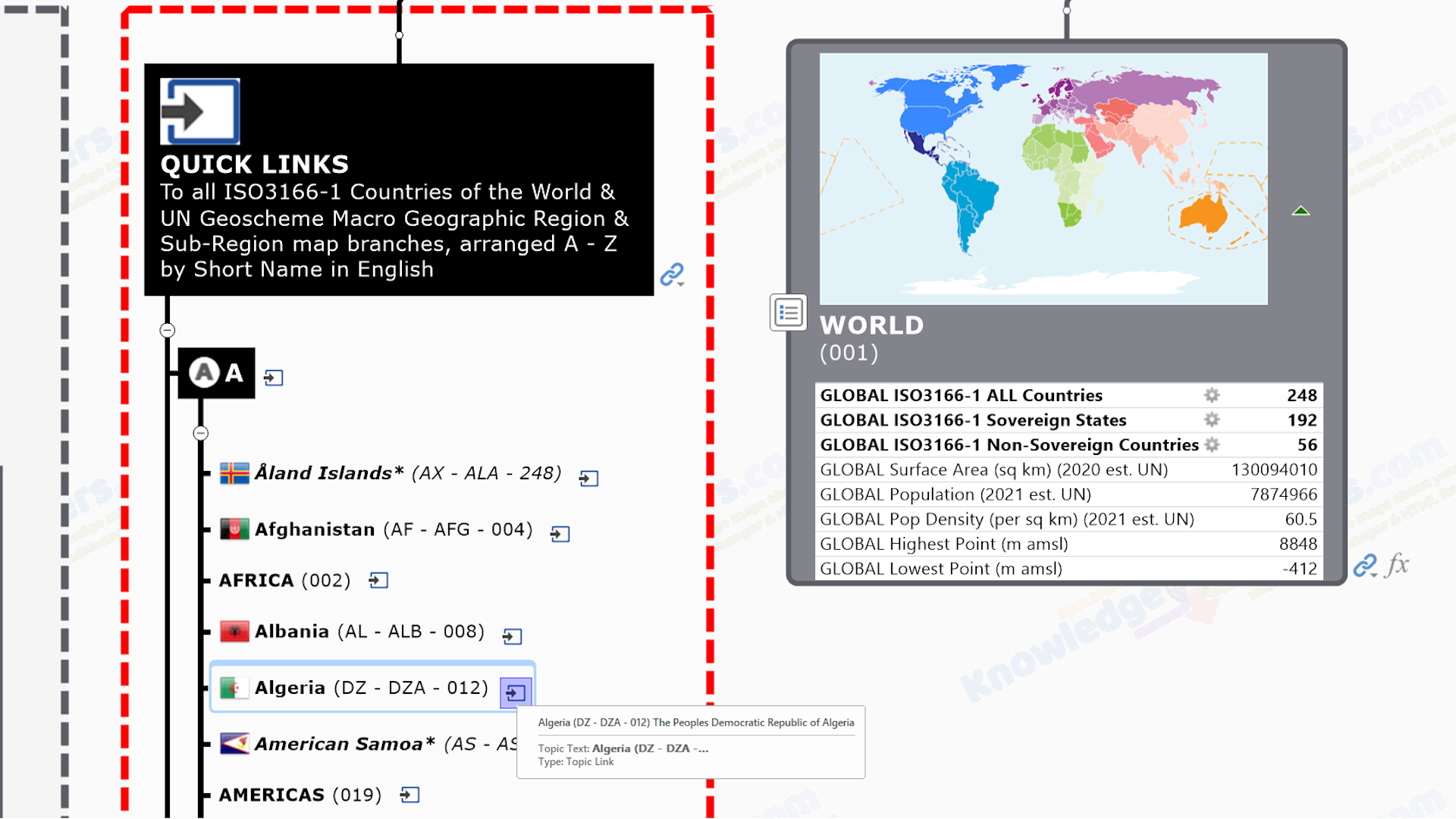
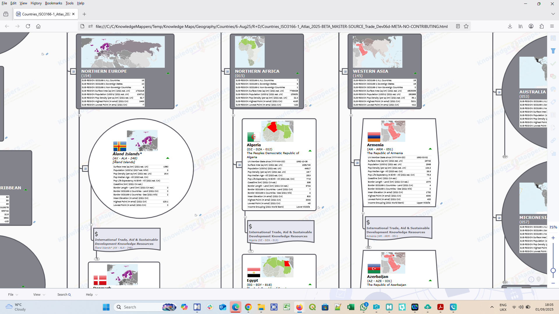
 Map the list of countries of the World – Let’s use MindManager to visually ‘mindmap’ the ‘official list’ of the Countries of the World, which is defined by the international standard ISO-3166-1: Codes For The Representation Of Names Of Countries.
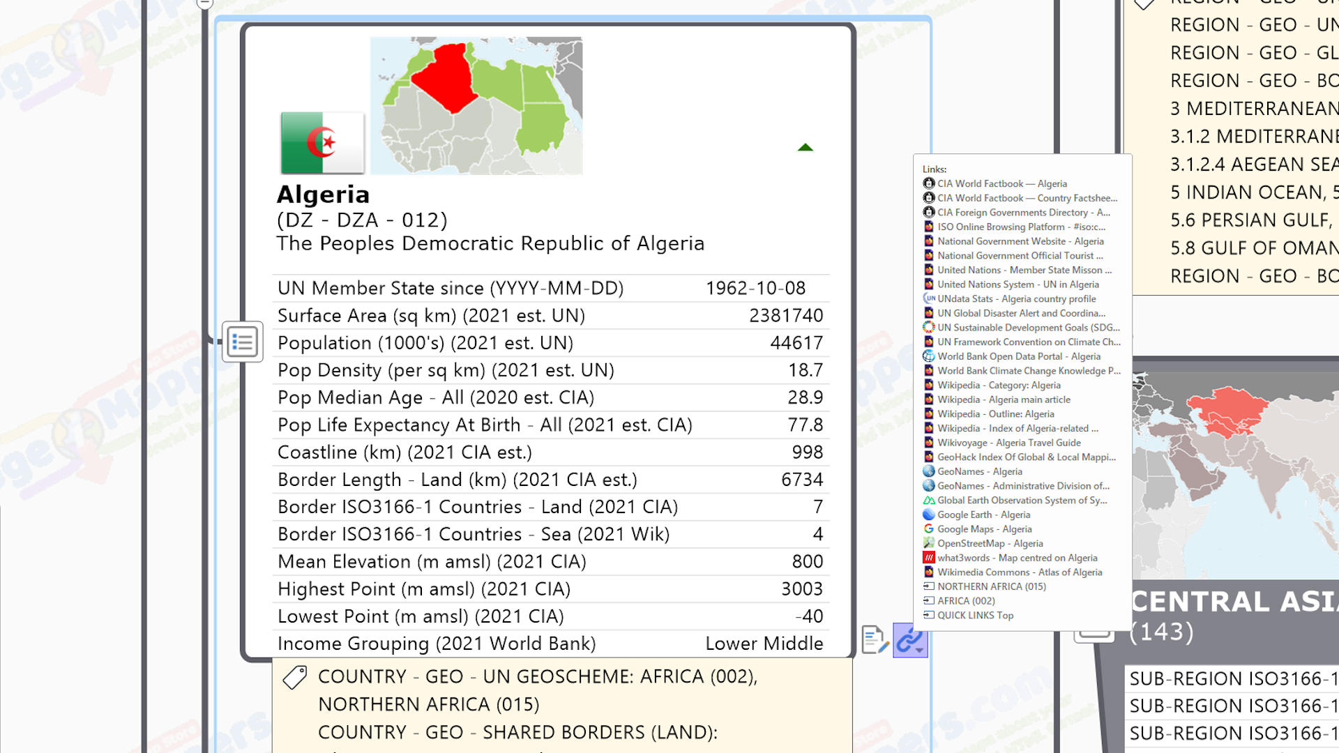
 Including other useful info – And because we know these things are important, let’s include as many useful fields from the official standard as we can squeeze onto a single map branch without overwhelming the user (so Short Name and Long Name, as well as all the alternative 2 and 3 letter, and 3 number, unique Identity Codes).
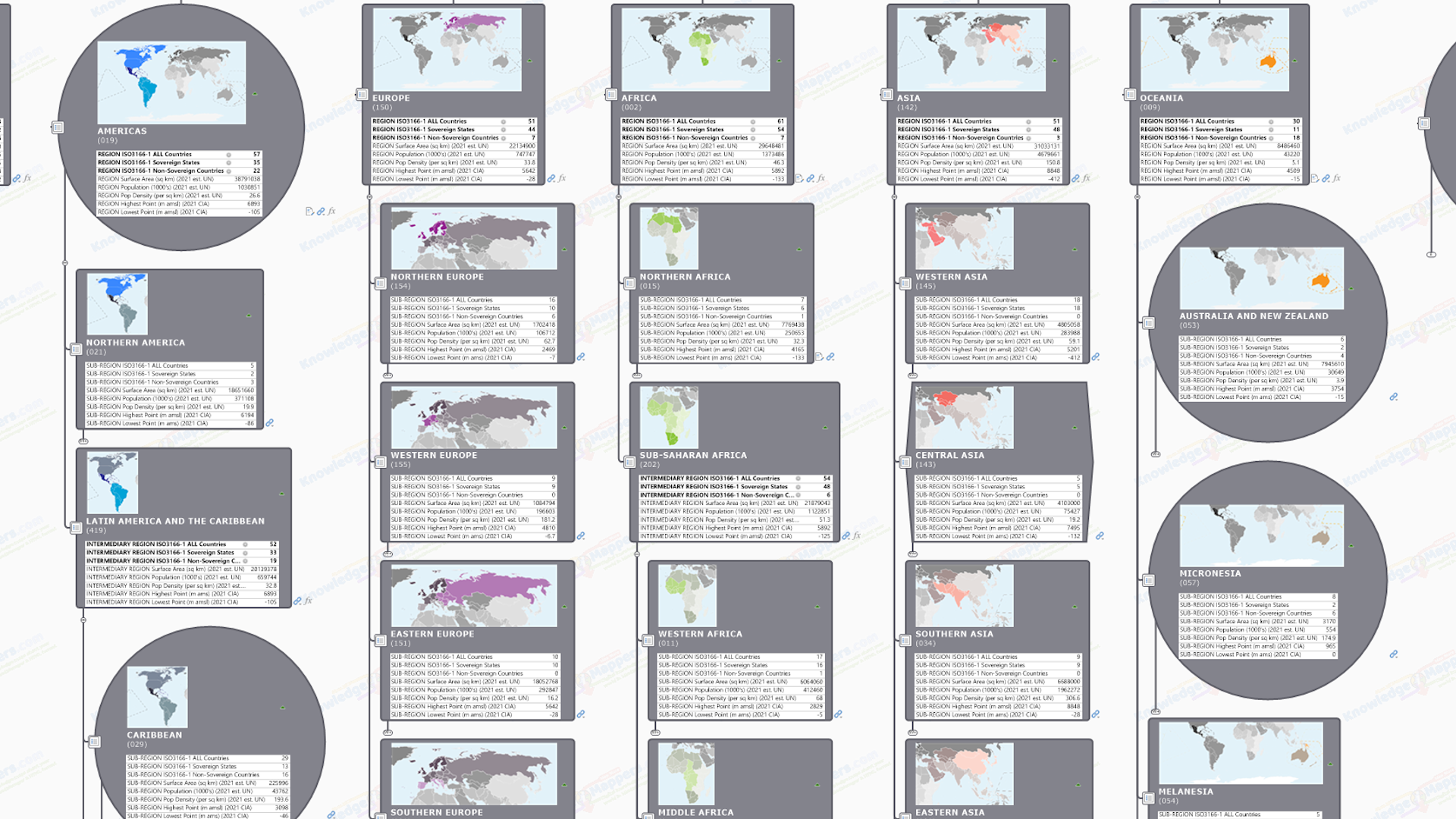
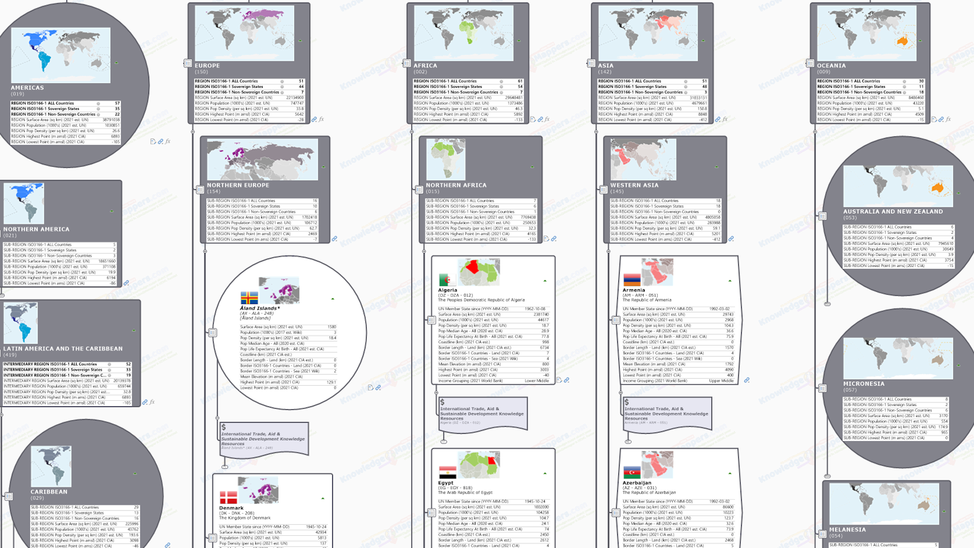
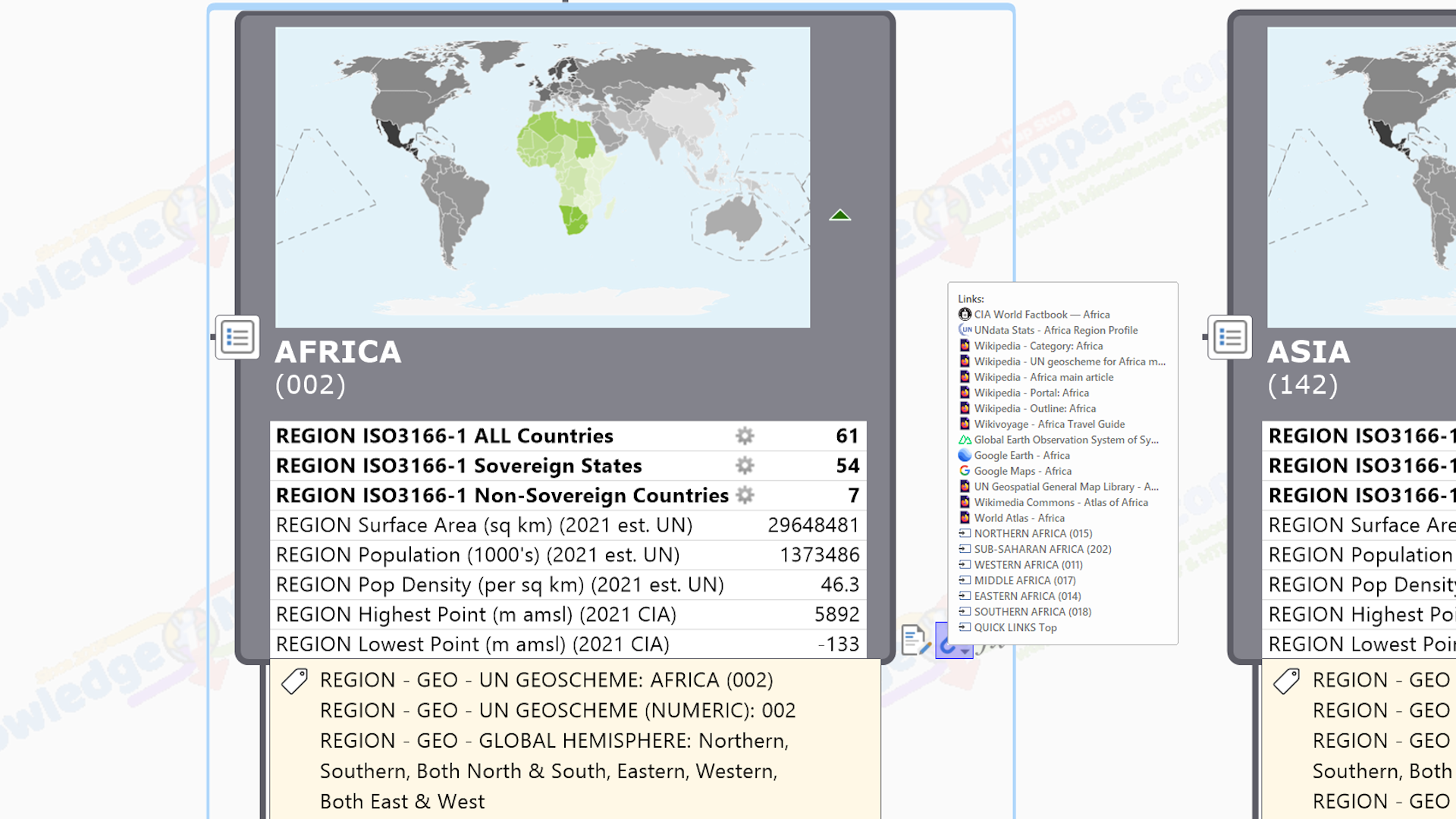
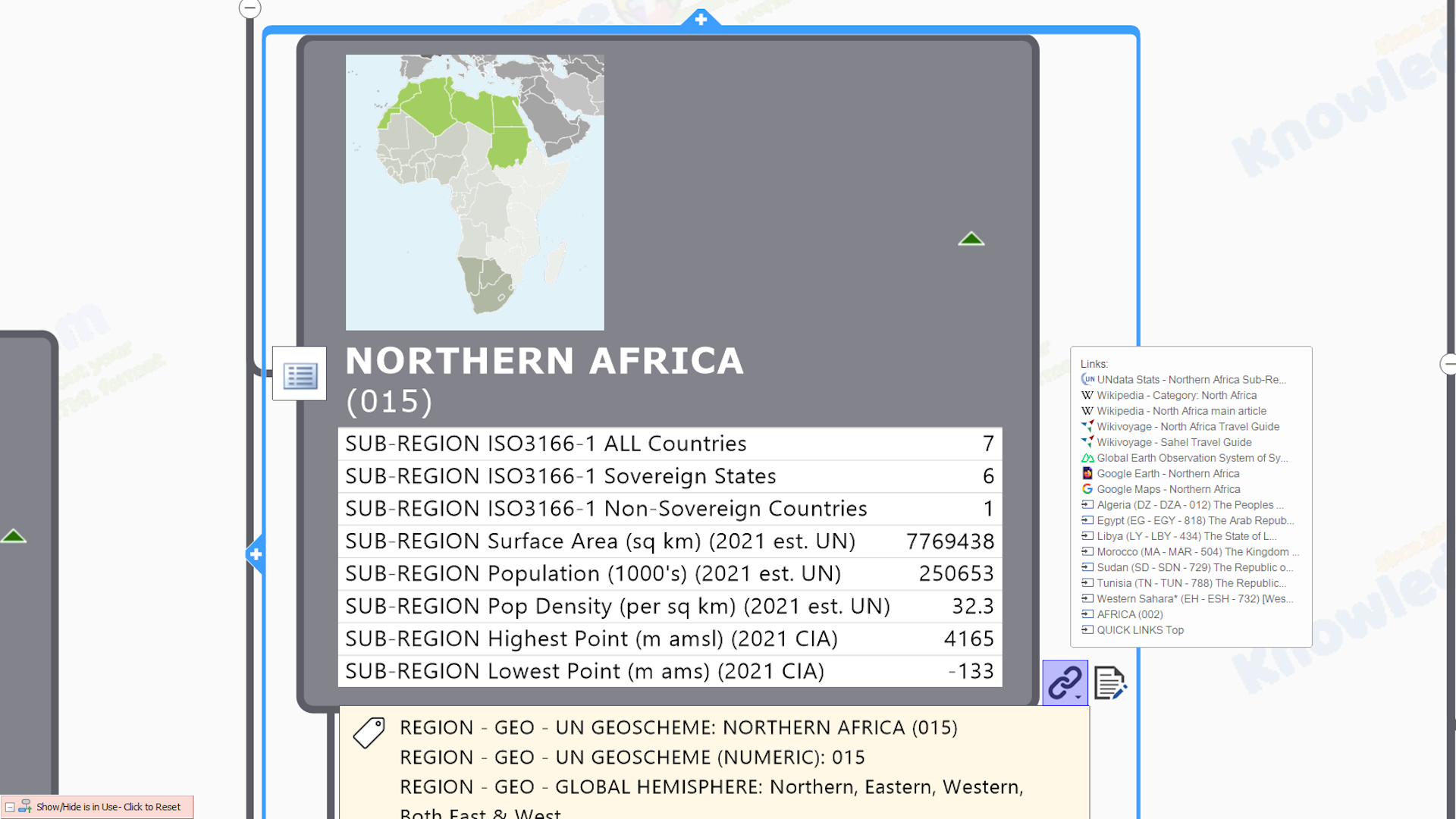
 Similarly map the Macro Regions and add the countries as sub-branches – Rather than just list the country map branches within an alphabetic hierarchy (A, B. C etc.), lets place them within the world’s macro geographic hierarchy of regions (‘continents) and sub-regions (ie. the equivelant you would see in the traditional ‘Map of the World’), which is officially defined by the United Nations M49 (‘Geoscheme’) standard, used to collect, analyze and map geostatistical data supplied by the different member states (and which also includes unique Identifying Codes, so lets’s make sure we include them as well).
 Add a unique location map image to each branch – Because we’re visual and we have the technical capability and MindManager allows it, let’s also add an image to each branch of the hierarchy that visually uniquely identifies each region, sub-region and country, say a simple location map that shows where it is in the world and in relation to neighbouring ‘building blocks’ (and flag if it’s a country).
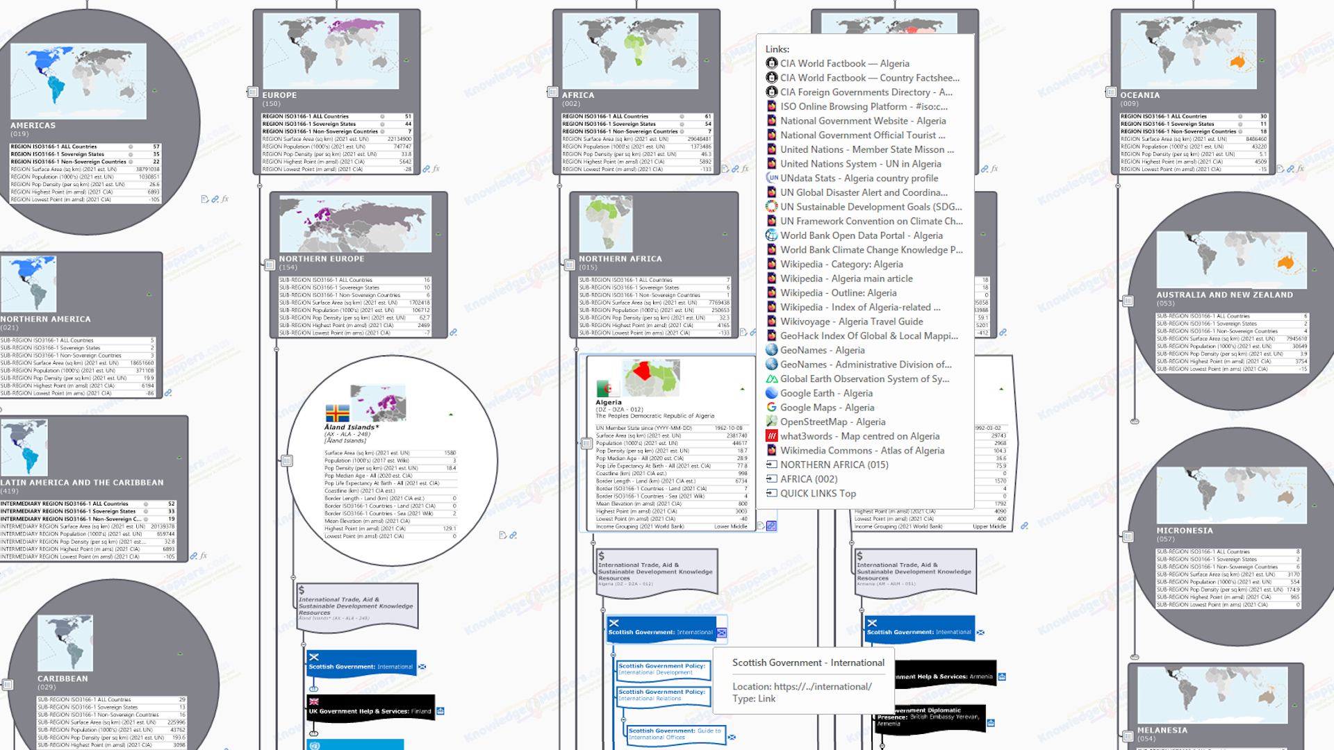
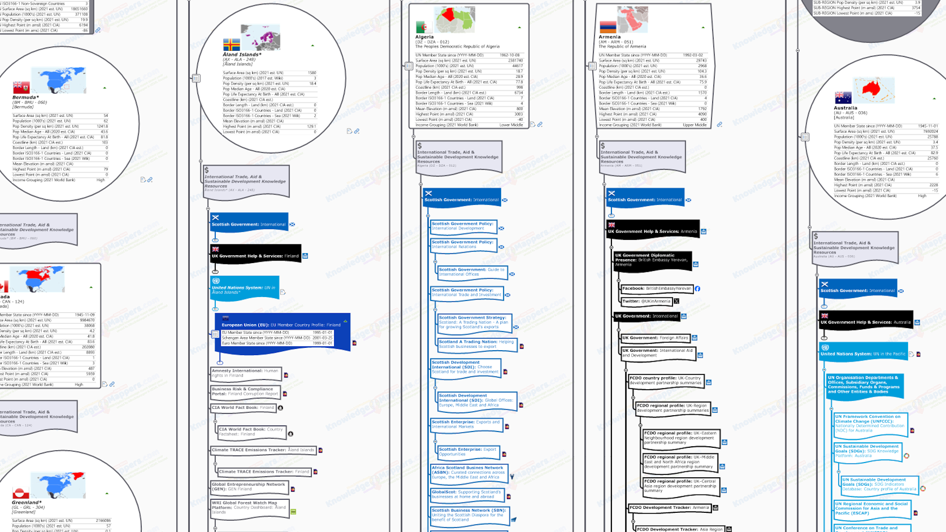
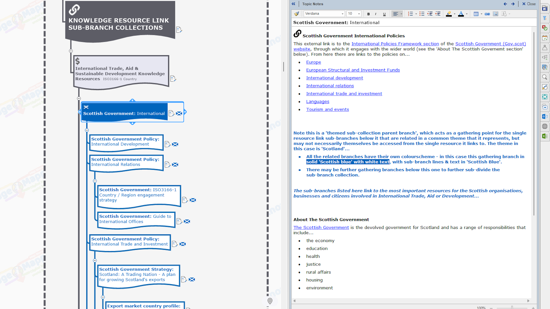
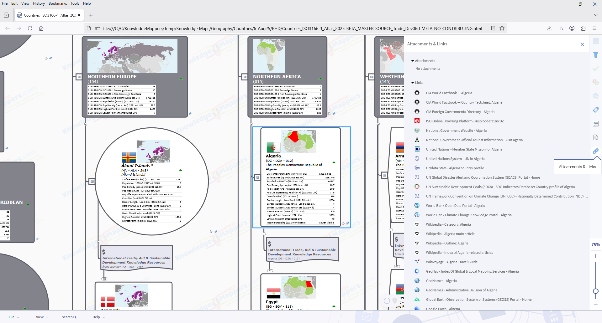
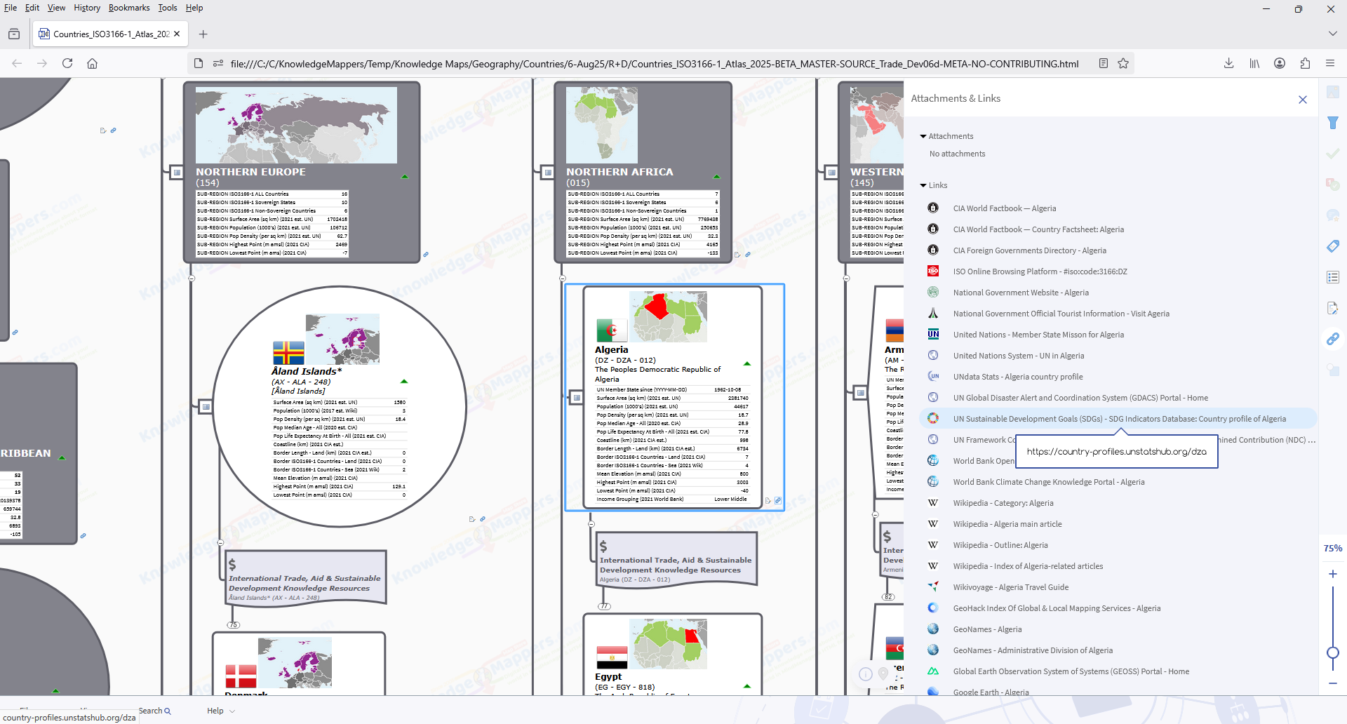
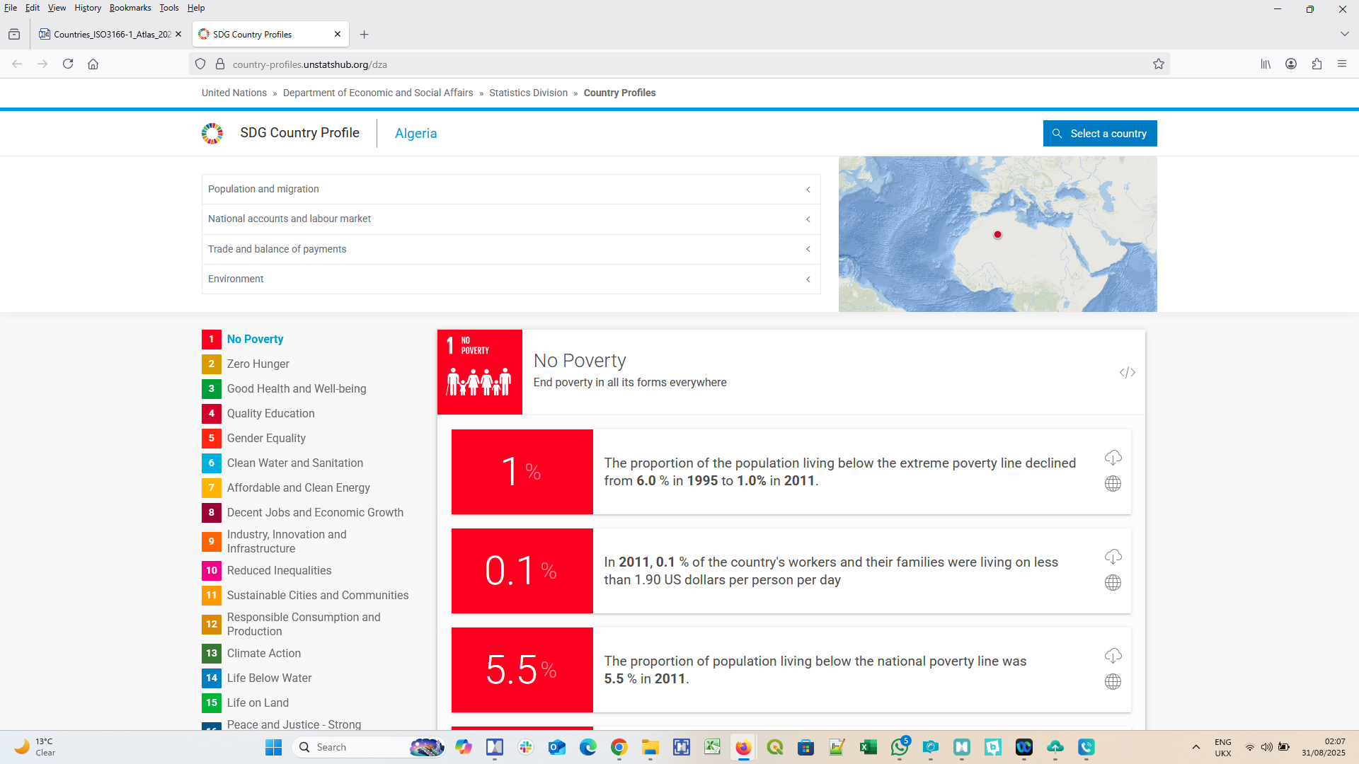
 Transform branches into ‘knowledge seed branches’ by first attaching knowledge resource links…. – Let’s turn those simple map branches into ‘knowledge seed branches’ by firstly attaching links to the core official / definitve / ‘plain old useful’ general & geographic knowledge resources about each country / sub-region / region ‘building block’ that we can find in the public domain – so 1000’s of links in total, made up of 10’s of links attached to the 100’s of branches (multiple links attached to a single branch is one of MindManager’s unique features).
 .…and then incorporating core, contextual general & geographic knowledge from these core, linked-to resources as either visual formatting or embedded / attached knowledge elements – Let’s really put those celebrated MindManager ‘information cartography’ features to work to create a single, intuitive to use, easy to navigate map that also visually conveys basic key knowledge using visual formatting and/or knowledge elements embedded within / attached to map branches. So for example….
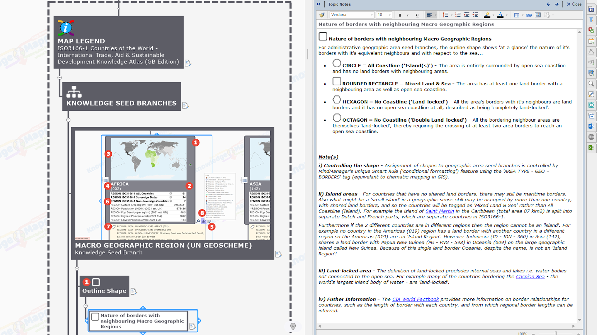
- Shape of branch indicating nature of borders of geographic area with respect to the sea (eg.
 all coastal (ie. an ‘island’),
  mixed land & sea,
  all land (ie. ‘land-locked’)).
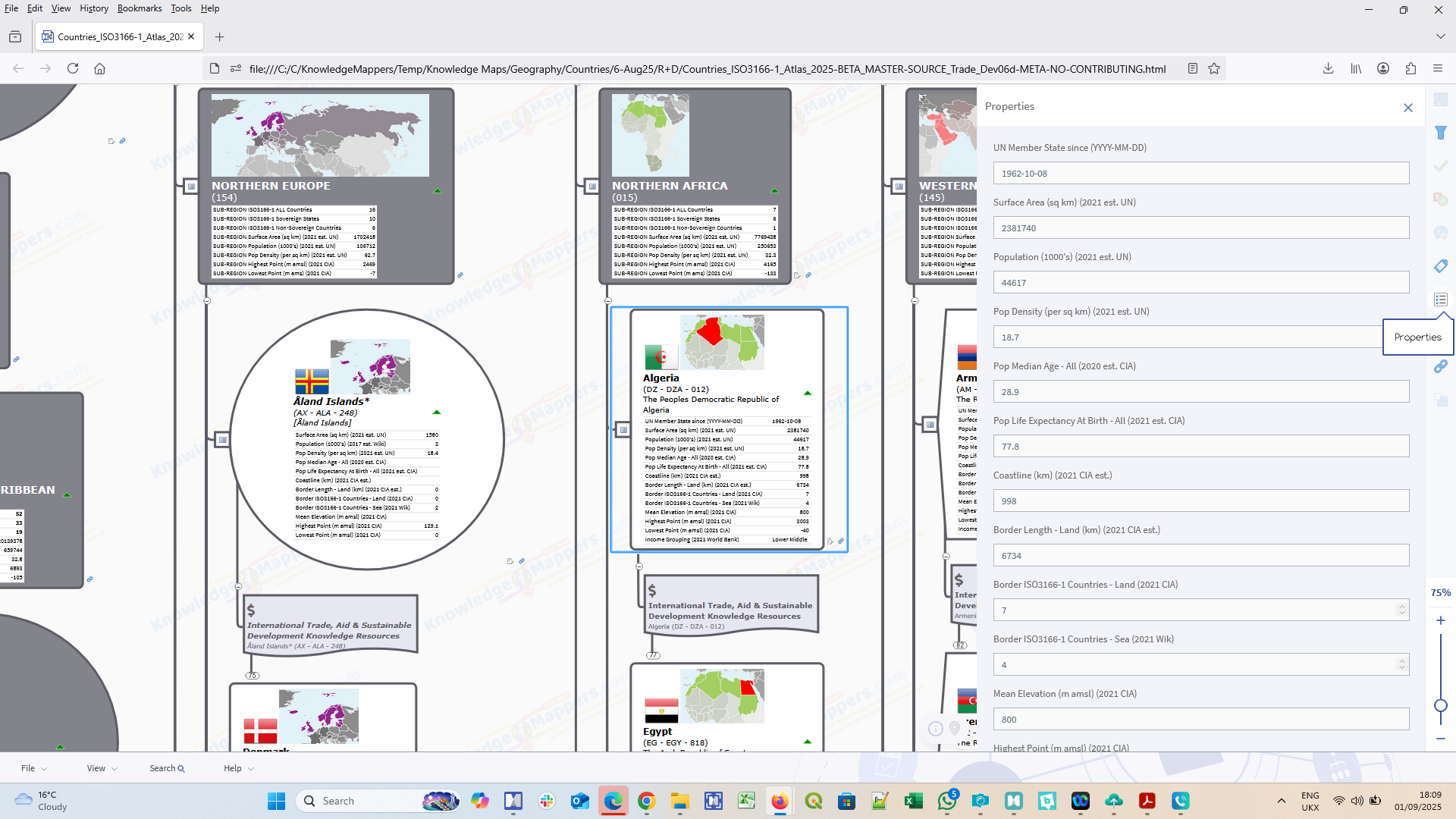
 - Geo-demographic statistics (published annually by the United Nations) embedded as
 Single Data Fields.
 - Geographic relationships between equivelant ‘blocks’ and other geographic features as attached
 Index Marker Tags (such as the other blocks it shares a border with, world oceans and seas it borders etc.).
.
 Give it a proper Map Legend – Let’s tidy it up and, like all good published maps, add a Map Legend that explains all the different types of map branches and all the different MindManager knowledge elements embedded within them or attached to them, and an explanation of where the information was sourced from and why.
 Publish final (for now 😉 map – The final stage of the process is publishing our Countries of the World – Base Knowledge Atlas, which we do as a native
  MindManager (.mmap) file and, using the unique export feature, an
  HTML5 (.html) file that retains all of the content and most of the interactivity of the original (with both being included in the product download)….
- HTML maps can be viewed by anybody with a web broswer, on any device, as a ‘read only’ reference resource to ‘look up’ the core general & geographic knowledge about the Regions, Sub-regions and Countries of the World contained in the map itself, and/or as a portal to the attached, linked-to, more comprehensive source knowledge resources about them, which can be discovered in-context and are no more than a couple of mouse clicks away.
- MindManager maps require MindManager software to be viewed (you can download a fully functioning, 30-day free trial here), and can be used for the same ‘read only’ purposes as the HTML map, but more importantly can also be edited, amended or re-purposed by MindManager users for their own purposes, such as using it as a template basemap upon which to map their own ‘Countries of the World’ based knowledge for their own purposes (eg. mapping international sales territories, teams and offices), perhaps even adding some information they newly discovered from the attached linked-to resources in the process; and/or used in whole or in part as a source of Region / Sub-region / Country ‘Geo’ content in their other maps.
.
Taking it further – Mappng the general and subject-specific knowledge resources themselves
So as with the geographic Countries of the World Map basemap, we want to be able to add to the basic, general geographic knowledge of the map ie. what are the countries of the world, which countries are where, and what other things are nearby (other countries, oceans etc.). In geographic maps we do this by either….
- visually reformatting the geographic blocks (ie. the countries) by colouring them different coulours or shades according to some attributed data value they have (known as thematic mapping); and/or
- adding an additional layer (or layers) of the specific geographic knowledge we want to map – represented by cartographic elements of points, lines or polygons – on top (eg. our suggested driving route between home and another place on top of a Google map).
.
Well it is actually possible to do the equivelant of both of these things routinely in MindManager using standard features, and which we already use in the Basemap. The combination of topic styles and smart rules features enables visual formatting of branches ‘triggered’ by a range of characteristics, including specific branch text strings, attached marker tags or values in embedded single data fields, and we’ve already talked about the wide range of MindManager elements that can be used to embed or attach knowledge to map branches.
In other words MindManager users can already create their own bespoke ‘Countries of the World’ based knowledge maps starting from our basemap (though remember we do offer a bespoke map creation service and/or training to help you make them for yourselves).
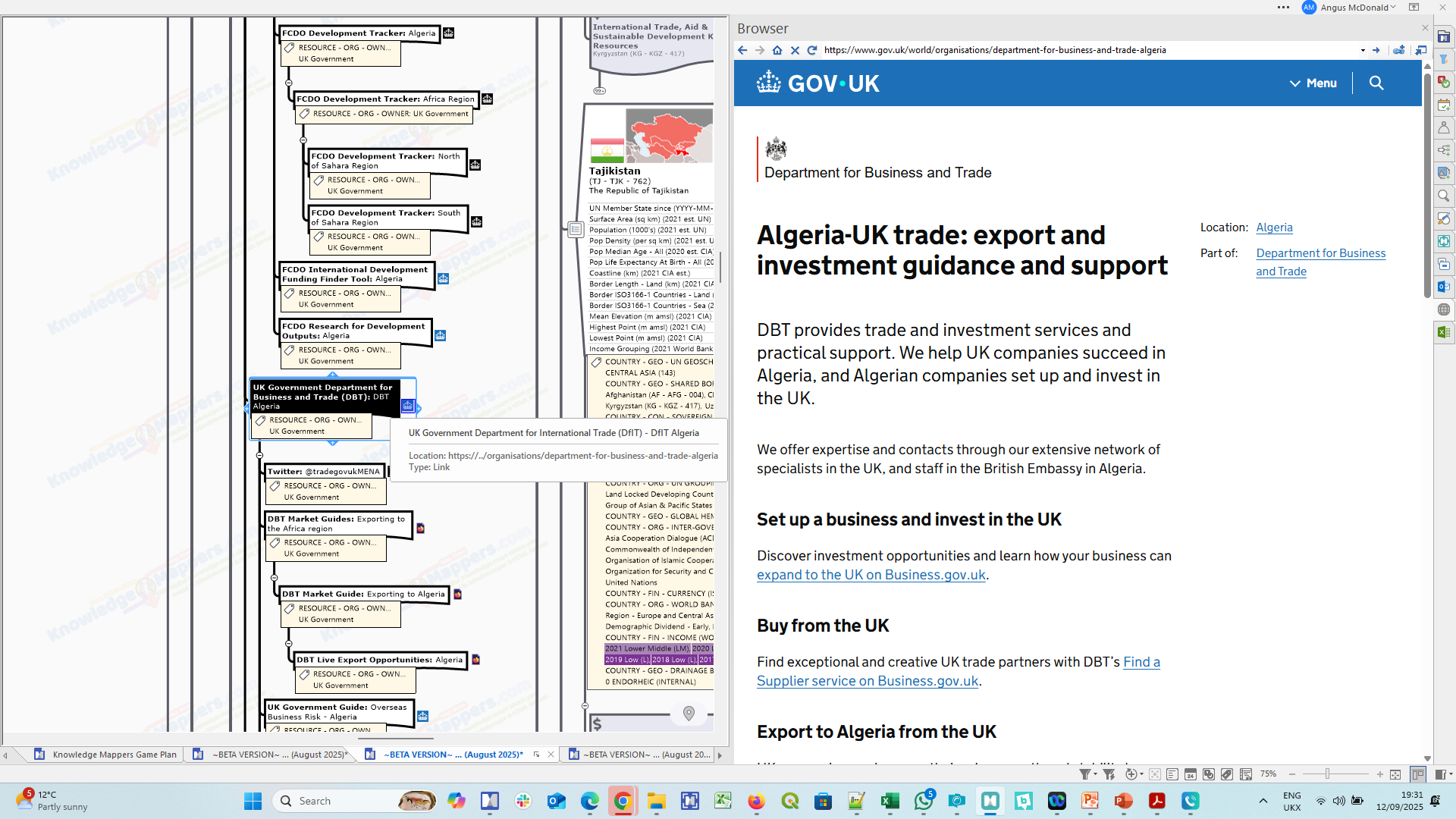
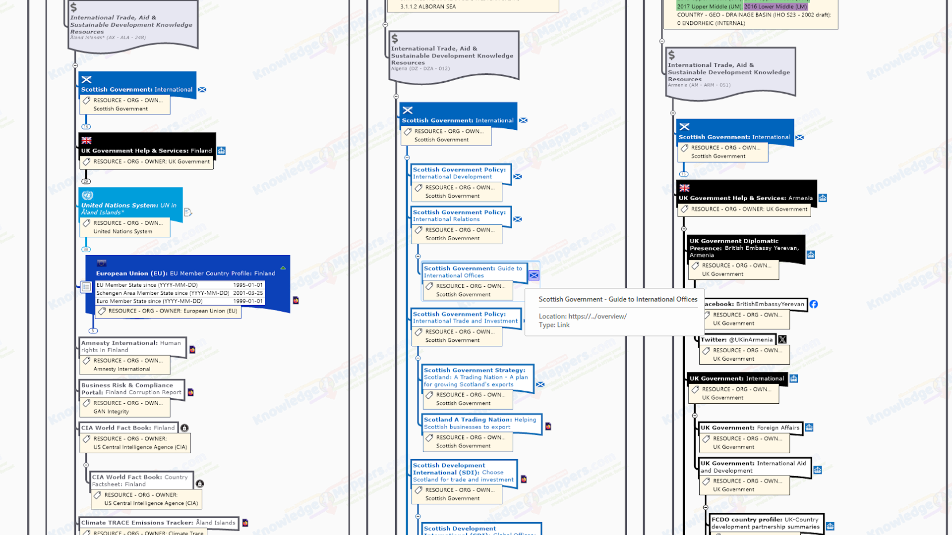
Which means there’s no point in us creating more specialised, ‘countries of the world’ knowldge maps that are of more limited general appeal as part of our store catalogue (well not initially anyway). Instead we decided a more important, and fundamental, thing to do would be to start mapping ALL the official / definitive / ‘plain old useful’, country-specific knowledge resources themselves, staring with the general & geographic resources we used to make the Basemap Atlas itself, and then moving on to more specialist knowledge areas for particular users (though still of broad interest).
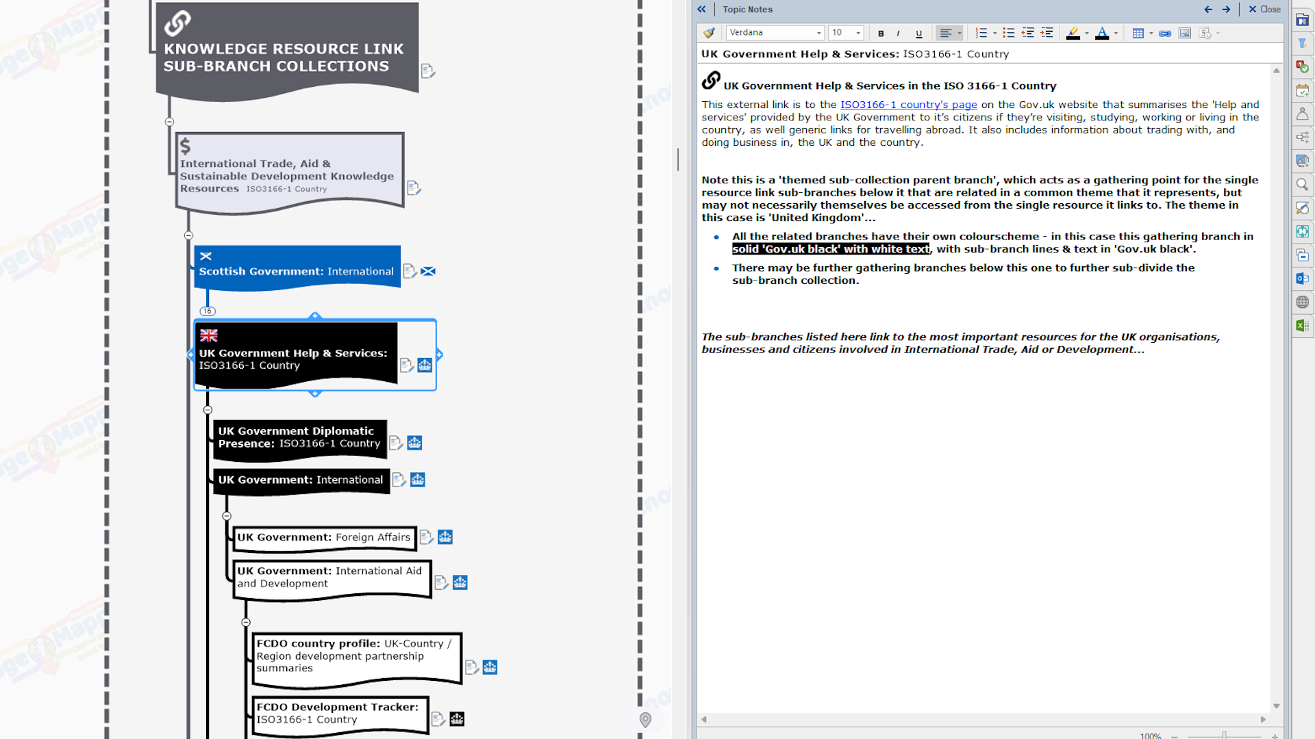
We do this by adding a further level (‘layer’) of sub-branches grouped in subject-related collections, one for each of the aforementioned subject-specific knowledge resources with it’s name as the branch text and a single link to it online attrached. This will make the knowledge resources more accessible and discoverable to ALL who have an interest in that subject through an intuitive to use map interface that can be viewed by anubody in a browser if they aren’t MindManager users. And if they are MindManager users, they can put them to work immediately to find the more specific source information they need to make their own bespoke, subject-related maps, all within the same software environment.
And so this gives rise to our next ‘tranche’ of Countries of the World Knowledge Atlas maps in our catalogue….
.
And further still – ‘Country-specific’ editions….
With the knowledge resources of universal appeal mapped in the General Editions, we can add further ‘layers’ of sub-collections of related knowledge resources aimed specifically at citizens and organisations from particular countries.
As we are based in Great Britain the first country-specific editions are….
.
Obviously there is scope for other ‘country editions’, but this will be limited to English language.
.
Or strip it back to basics….
We realise that users don’t need or want ‘all the bells and whistles’ of the Base Knowledge Atlas map for every project. Sometimes they just want the basic map branch hierarchy that they can then edit / amend / add to entirely at their own discetion.
It is a straightforward enough task to remove embedded / attached features within MindManager, individually or en masse, but rather then leaving it to individual users to have to do that, we have decided to publish a Basic Knowledge Atlas edition that is ‘stripped back’ to the basic branch framework ie. no attached  hyperlinks or tags, an no
  embedded single data fields.
This will be available shortly.


